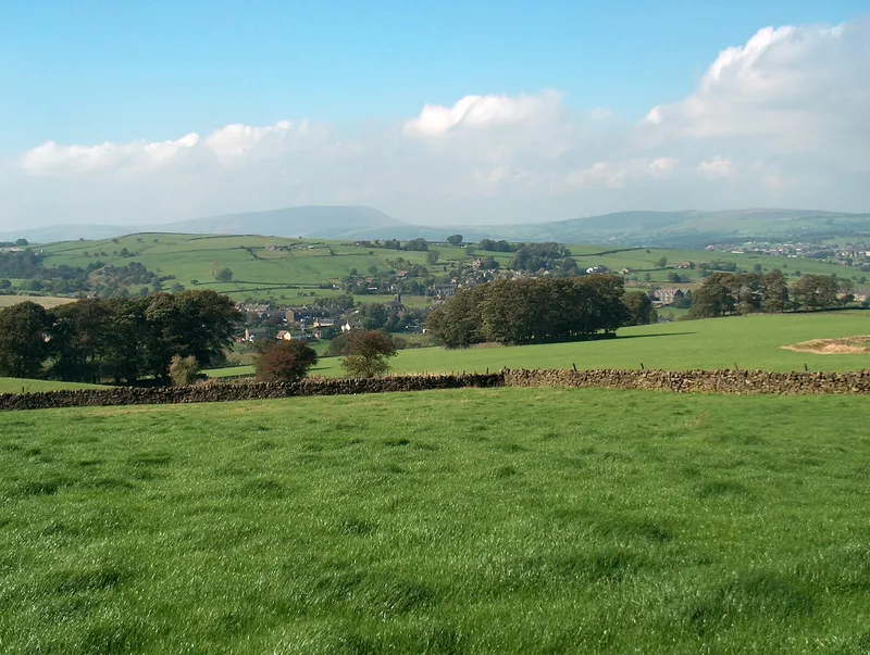
Green fields above Trawden with Pendle Hill on the skyline

Photo: Bill Boaden, CC BY-SA 2.0

Walks from Trawden

Walks from Trawden, from the front door

Lace up at the cottage. Gentle family strolls, Wycoller and the Brontës, and the big climb onto Boulsworth Hill.

Pull on your boots at the door. Spring Cottage sits in the old Forest of Trawden, right where Lancashire's green fields give way to the high moors of the Yorkshire border. From the cottage you can walk to Wycoller, with its packhorse bridges and the ruined hall tied to Jane Eyre, climb Boulsworth Hill (the highest point in the South Pennines), or wander down to the community-owned Trawden Arms. A short drive takes you to Pendle Hill, the reservoirs and canal at Foulridge, and the Brontës' own moors above Haworth. Here are our favourite walks, from gentle family strolls to proper big days out.

Printable walk guides with maps and directions are available to download for every walk below. Also: The Spring Cottage guide to Trawden & Pendle, 5MB (PDF) · The Ultimate Guide (phone edition) (PDF) · The Ultimate Guide to Pendle, Lancashire and the Yorkshire Dales (A5 print) (PDF)

Safety and the Countryside Code

These are real Pennine walks. Paths cross working farmland and open moor, and the weather can change fast on the tops. Wear waterproof boots, carry a waterproof layer, water and a map (OS Explorer OL21 South Pennines covers Trawden, Wycoller and Boulsworth; OL41 covers Pendle Hill), and tell someone your route. Phone signal can be patchy. Please follow the Countryside Code:

  • Leave gates as you find them, and keep to marked paths unless you're on open access land.
  • Don't block gateways or lanes when you park.
  • Take your litter home, and bag and bin your dog's poo.
  • Dogs: keep them under control and in sight, and on a lead around livestock. On Open Access land (most of the moorland here) the law says dogs must be on a lead from 1 March to 31 July, and around livestock at any time of year. If cattle threaten you, let your dog off the lead so you can both get to safety.
  • Moorland fires are devastating. Don't light fires or BBQs.

The Countryside Code on GOV.UK ↗

FROM THE COTTAGE DOOR

1. Trawden to Wycoller (and on to Laneshaw Bridge)

4 miles (6 km)Easy to moderate

Download the printable walk guide (PDF)

Step out of the cottage, past the community-owned Trawden Arms and up the old tram tracks, and within the hour you'll be crossing pulpit stiles above the Wycoller valley with Pendle Hill on the skyline. Wycoller is a gem: a ruined hall said to be Charlotte Brontë's Ferndean Manor, a packhorse bridge built before 1550 and a clapper bridge polished by centuries of clogs. Take a picnic (there's no longer a café in Wycoller), then walk back the way you came or carry on past old golf links and herons to the Emmott Arms at Laneshaw Bridge.

Highlights along the way

Trawden Arms (built 1895 on the site of a 16th-century corn mill), Poetry Corner at the bottom of Rock Lane, the old tram tracks, St Mary's church (1846), Germany Farm, two sturdy pulpit stiles, views to Pendle Hill with Boulsworth behind. At Wycoller: the ruined hall said to be Ferndean Manor in Jane Eyre, the pre-1550 packhorse bridge "Sallie's Brig" and a clapper bridge worn by generations of clogs. Then past Lowlands Farm and the old St Andrew's golf course (closed 1948), where herons and deer are often seen, to Carriers Row.

Start
Trawden Arms, Trawden village. Linear walk, finishing at the Emmott Arms, Laneshaw Bridge. Turn back at Wycoller for a there-and-back, or walk the full route.
Distance / time
4 miles (6 km), about 2.5 hours (full one-way route).
Difficulty
Easy to moderate. Mostly well-defined paths, with one short road section in Trawden. Some paths are hard going after wet weather.
Pub / café
Trawden Arms (start); Emmott Arms (finish). No café in Wycoller now (the tearooms closed in 2023), so take a picnic. Toilets at Wycoller and Laneshaw Bridge.
Dogs
Farmland and stiles, including pulpit stiles. Lead near livestock.
Parking
None needed. Walk from the cottage.
Getting there
The leaflet lists Burnley & Pendle bus service 21.

Full route page: Trawden to Wycoller →

Source ↗

2. Boulsworth Hill via Lumb Spout (short summit loop)

5.5 milesModerate

Download the printable walk guide (PDF)

Boulsworth is the great moorland hill above Trawden, and this is the quickest way up it from the door. Start with a muddy little detour to Lumb Spout, a hidden waterfall that drew Victorian day-trippers, then climb the waterboard path onto the moor. Up top, gritstone tors called Little Chair Stones and Weather Stones make perfect picnic seats. From Lad Law, the highest point in the South Pennines, the view runs from Pendle Hill to the Yorkshire Three Peaks. Allow half a day and save your appetite for the Trawden Arms.

Highlights along the way

Lumb Spout waterfall (a short, muddy detour). Visit Pendle calls it Pendle's highest waterfall, and it was a popular spot with Victorian visitors. Little Chair Stones and Weather Stones on the summit plateau. Lad Law (517 m) is the highest point in the South Pennines. On a clear day you can see Pendle Hill, the Bowland moors, Ingleborough, Pen-y-ghent and Great Whernside.

Start
Trawden village (grid ref SD911386, by St Mary's church).
Distance / time
5.5 miles, ascent 1,337 ft (about 408 m), about 3.5 hours.
Difficulty
Moderate. A steady climb on a concessionary path onto open moor, with some wet sections on the way down.
Pub / café
Trawden Arms on return. Nothing on the hill.
Dogs
Open moorland with sheep. The access-land lead rule applies (1 Mar to 31 Jul).
Parking
None needed. On-street parking near the church is limited.

Full route page: Lumb Spout and Boulsworth Hill →

Source 1 ↗ · Source 2 ↗

3. Boulsworth Hill Ridge & Wycoller: the big Trawden day

10 miles (16.3 km)Moderate

Download the printable walk guide (PDF)

For walkers who want the full Pennine experience without touching the car. Head out along the lane to Hollin Hall, then make a stiff climb past the extraordinary Abbot Stone to Lad Law's trig point. From there, follow the wild ridge east among weather-carved gritstone tors (the Saucer Stones, Weather Stones, Crow Hill) and drop to lonely Watersheddles Reservoir on the Yorkshire border. The Brontë Way then leads you down Wycoller Dean to the ruined hall and the ancient bridges, a good picnic spot before the field paths home. Ten glorious miles. Pack a proper lunch.

Highlights along the way

Slack Laithe and Meadow Bottom farms, Gilford Clough, the Pennine Bridleway, the Abbot Stone (a big upright gritstone slab), the Lad Law trig point (518 m) with a 360° panorama, then the Weather Stones and the Little and Great Saucer Stones. East over Crow Hill and down to Watersheddles Reservoir, onto the Brontë Way past Parson Lee Farm, then along Wycoller Beck into Wycoller, past the ruined hall and over the two-arch bridge. Back over the fields by Bracken Hill and Higher Stunstead.

Start
Near St Mary's church, Trawden (SD911386). Limited on-street parking.
Distance / time
10 miles (16.3 km), ascent 1,400 ft (424 m), about 6 hours.
Difficulty
Moderate. There's a stiff climb onto the ridge and only a vague path along it, so navigation skills are needed in mist.
Pub / café
Trawden Arms (finish). No café at Wycoller now, so take a picnic.
Dogs
Several ladder stiles (at Watersheddles), so this suits fit dogs that can be lifted. Open moor with sheep, so the access-land lead rules apply.

Full route page: Boulsworth Hill ridge and Wycoller →

Route map ↗ · GPX route ↗ · Source ↗

4. Coldwell Reservoirs, Bedding Hill Moor & Wycoller

7.5 miles (12 km)

Download the printable walk guide (PDF)

A big moorland round with no summit to slog up. Follow the Pendle Way out of Trawden to the Coldwell reservoirs, which shine below Boulsworth's long flank, then pick up the Brontë Way across Deerstone and Will Moors. It's wide, quiet, big-sky country. The descent off Bedding Hill Moor brings you down to Dean House Farm and into Wycoller, where the packhorse bridge makes a perfect picnic pause before the last fields back to the cottage. Feeling energetic? The sister route adds the climb to Lad Law.

Highlights along the way

The two Coldwell reservoirs below Boulsworth, open moor on the Brontë Way, and Wycoller's bridges and hall on the way home.

Start
Trawden village.
Distance / time
7.5 miles (12 km), ascent 1,076 ft (328 m), about 4 hours. Graded moderate, described as a "lovely walk with one (avoidable) steep climb".
Pub / café
Trawden Arms at the end (no café in Wycoller now). Note: the old Coldwell Inn is now Coldwell Activity Centre, a charity-run group-accommodation centre, not a public café or pub. Take a picnic.
Dogs
Moorland and farmland with sheep. Lead rules as above.

Full route page: Coldwell Reservoirs, Bedding Hill Moor and Wycoller →

GPX route ↗ · Route map ↗ · Source 1 ↗ · Source 2 ↗

5. Winewall & Laneshaw Bridge Circular

5¾ miles (short version 4½ miles)Easy to moderate

Download the printable walk guide (PDF)

A gentle, history-packed loop through the farmland on Trawden's doorstep, with old farmhouses, drystone walls and a story at every turn. You'll pass the church whose young curate proposed to Charlotte Brontë (she said no), a Georgian poor house, the farm where a tree was said to blossom every Christmas Eve, and the little Inghamite chapel at Winewall where 700 came to hear a firebrand preacher in 1755. Three country pubs are on or near the route, so plan your lunch with care.

Highlights along the way

Christ Church, Colne (1836). Its first curate, Rev. David Pryce, proposed to Charlotte Brontë in 1839 and she turned him down. Also the old Flass poor house, Laneshaw Bridge, Stunstead House (home of the Midgeley family from 1694 to 1869), Well Head (the source of a 1914 typhoid outbreak), and Winewall's former Inghamite chapel, where 700 people heard Benjamin Ingham preach in 1755. Winewall itself dates back to at least 1260 as a cattle farm, or vaccary.

Start
Lower car park, Ball Grove Park, Colne. The loop runs through Winewall on the edge of Trawden and past Higher Stunstead, so you can also join it on foot from the cottage (Winewall postcode BB8 8EN).
Distance / time
5¾ miles (short version 4½ miles), 2 to 4 hours.
Difficulty
Easy to moderate. The leaflet calls it "a more gentle walk" but warns there are some stiles.
Pub / café
Alma Inn, Emmott Arms (Laneshaw Bridge) and Cotton Tree, plus the Lakeside Café at Ball Grove.
Dogs
The leaflet asks you to keep dogs on a lead. Farmyards and stiles.
Parking
Ball Grove Park car park.

Source ↗

FAMILY & EASY

6. Wycoller Panopticon (Atom) Walk

2.5 km (just over 1.5 miles)Easy, but the path is very narrow in places, with a ladder stile and some kissing gates

Download the printable walk guide (PDF)

The perfect hour for small legs. Start inside the Atom, a strange, beautiful pod perched above the valley, where each round window frames a different view and a hidden steel ball reflects the whole landscape back at you. Then follow a narrow path past Foster's Leap, where a daredevil Cunliffe is said to have jumped a rocky chasm, and down past waterfalls to Wycoller's prehistoric Clam Bridge and the willow tunnel. Pack a picnic: the old tearoom has closed.

Highlights along the way

The Atom, a ferro-cement panopticon by Peter Meacock with a hidden polished-steel ball inside and windows framing Pendle Hill. Foster's Leap rock, named after a Cunliffe who supposedly jumped the gap. Parson Lee Farm, waterfalls, larch and beech trees, Water Meetings, the prehistoric Clam Bridge, Copy House Bridge (rebuilt 1992), a live willow tunnel and the Aisled Barn visitor centre.

Start
Haworth Road car park for Wycoller Country Park, next to the Atom sculpture. From Laneshaw Bridge, take the minor road signposted Haworth and after about 2 miles the car park is on the right. (The LDWA gives the postcode BB8 7EQ for this car park.)
Distance / time
2.5 km (just over 1.5 miles), about 1 hour.
Difficulty
Easy, but the path is very narrow in places, with a ladder stile and some kissing gates.
Pub / café
None in Wycoller now (the tearooms closed in 2023). Take a picnic; the Trawden Arms is back in the village.
Dogs
There's a ladder stile (the gate beside it is "usually open") and you cross a private garden at Foster's Leap Barn, so keep dogs on leads.

Source ↗

7. Wycoller Country Park Circular

6.4 km (4 miles)Easy

Download the printable walk guide (PDF)

Wycoller is a hamlet that time forgot, and this easy loop shows it off beautifully. Wander the beck past the ruined Elizabethan hall that Charlotte Brontë is said to have used for Ferndean Manor, then cross some of the seven ancient bridges, from a single slab of stone to the humped packhorse bridge. A gentle climb brings you up onto the fell for views across to Pendle Hill before you drop back down to the hamlet. Dogs will love the shallow, sparkling beck.

Highlights along the way

The ruined hall, built by the Hartley family in the 16th century (its grand fireplace survives) and reputedly Ferndean Manor in Jane Eyre. The Aisled Barn from the 1630s, and seven bridges over Wycoller Beck, including the Clam, Clapper and Packhorse bridges. Views to Pendle Hill.

Start
Wycoller Country Park car park, Wycoller Road, Colne BB8 8SY (free).
Distance / time
6.4 km (4 miles), about 131 m ascent, about 2 hours.
Difficulty
Easy. A gradual climb from the valley floor onto open fell, rougher underfoot on the moorland.
Pub / café
None in Wycoller now (the tearooms closed in 2023). Toilets and visitor centre at the country park.
Dogs
Rated 8/10 for dogs by The Wildpack Collective. The beck is clear and shallow, with lots of easy paddling spots. But sheep graze both the valley and the fell, so expect to keep dogs on a lead for most of the walk.

Source 1 ↗ · Source 2 ↗

8. Ball Grove Park & the East Colne Way

Ball Grove Park circular is 2.4 kmThe park loop is easy, with benches, a play area and paths that can be muddy after rain

Download the printable walk guide (PDF)

A rainy-day saviour and a toddler favourite. Ball Grove was once a mill and tannery, and it's now a peaceful nature reserve, with a pond, a play area and riverside paths along Colne Water. There's also a café for hot chocolate afterwards. For a longer walk, the five-mile East Colne Way heads up past the Hartley jam family's almshouses and over Noyna Hill and The Rough, where curlews call in spring, before looping back via Foulridge Upper Reservoir.

Highlights along the way

Ball Grove pond and Colne Water. The site was a 1780s spinning mill and later a tannery the leaflet calls the biggest in Europe, and it's now a Local Nature Reserve. On the longer loop: the Hartley Homes almshouses (1911, given by the jam-maker Sir William Hartley), an Edward VII post box, Heyroyd House, the rocky outcrop of Noyna Hill, The Rough (where curlews nest in spring), Foulridge Upper Reservoir, and the Lidgett & Bents weavers' cottages.

Start
Ball Grove Park car park, Grove Drive, Colne BB8 7HY (by the Lakeside Café).
Distance / time
Ball Grove Park circular is 2.4 km, 30 minutes to 1 hour, easy. The East Colne Way extension is 5 miles, 2 to 3 hours.
Difficulty
The park loop is easy, with benches, a play area and paths that can be muddy after rain. The East Colne Way crosses farmyards and fields, with some stiles.
Pub / café
Lakeside Café at Ball Grove.
Dogs
Good for a short leg-stretch. On the East Colne Way the leaflet asks for dogs on leads. Curlews nest on the ground at The Rough in spring.

Source 1 ↗ · Source 2 ↗

9. Foulridge Reservoirs (Lake Burwain)

5.6 kmEasy and mostly flat, on waterside and farmland paths

Download the printable walk guide (PDF)

A flat, friendly loop that's ideal for families and easy-going dogs. Lake Burwain was dug in 1793 to keep the Leeds & Liverpool Canal topped up, and today it's home to a sailing club, grebes and coots, with reed buntings singing in the margins. The path mixes waterside and field edges, with plenty of spots for a picnic. Park considerately on the lane, then reward yourselves at one of Foulridge's village pubs afterwards.

Highlights along the way

Foulridge Lower Reservoir (Lake Burwain), built in 1793 to feed the Leeds & Liverpool Canal, and the Upper Reservoir. Look out for sailing dinghies, great crested grebes and coots, and listen for reed buntings. There are good picnic spots.

Start
Foulridge, near Colne. There's very limited roadside parking on a narrow lane at the trailhead. The sailing club car park is for members only.
Distance / time
5.6 km, 58 m ascent, 1 to 1.5 hours.
Difficulty
Easy and mostly flat, on waterside and farmland paths. Very muddy in wet weather.
Pub / café
Foulridge has pubs and cafés (for example the Hole in the Wall by the canal wharf).
Dogs
Walkers' reviews describe it as dog-friendly, with mostly open fields. One reviewer met only one field of sheep, but expect livestock in places.

Source ↗
BIG DAYS OUT (short drive)

10. Foulridge Mile Tunnel, Blacko Tower & the Lower Reservoir

6 miles

Download the printable walk guide (PDF)

Canal history, witch country and a folly tower in one easy six-mile loop. First, a tip: locals say "Foal-ridge". Start at the wharf by the mouth of the Mile Tunnel, where bargemen once "legged" boats through the darkness, and amble along the towpath. Then climb past a working cotton mill and the Fanny Grey pub to a high lane with views to the Dales. Pass Blacko Tower, a grocer's folly that turned out too short to see the Ribble Valley, and near the lost home of Pendle witch Old Demdike. You finish along the shore of Lake Burwain.

Highlights along the way

The Leeds & Liverpool Canal towpath to Mill Hill Bridge. At the wharf is the eastern end of the 1,640-yard Foulridge "Mile Tunnel", where bargees once "legged" boats through by lying on their backs and walking along the roof. The route passes a working cotton mill and the Fanny Grey pub, then climbs a moor-top lane with views to Skipton and the Dales one way and over Colne and Nelson the other. It passes within 200 yards of Blacko (Stansfield) Tower, built in 1890 by a grocer, and near the site of Malkin Tower, home of the Pendle witch Old Demdike. It returns along a paved path beside Foulridge Lower Reservoir.

Start
Foulridge Canal Wharf (car park beside a restored lime kiln).
Distance / time
6 miles, about 3 hours. Easy.
Pub / café
Fanny Grey (on route) and the pubs in Foulridge.
Dogs
Stiles, including one "tricky" one, plus farm dogs and curious young cattle. Lead on.

Source 1 ↗ · Source 2 ↗

11. Pendle Hill from Barley

5 miles (8 km)Grade 2-C: a medium-length walk with rugged terrain and steep climbs

Download the printable walk guide (PDF)

You'll see Pendle from all over the valley, so you may as well climb it. This is the classic circuit: a gentle warm-up past the Ogden reservoirs, then a steady, cairn-marked climb onto the great whaleback summit. On a clear day you can pick out Blackpool Tower, the Lake District and the Yorkshire Three Peaks. Come down the famous stone steps into Barley, where the Pendle Inn and a cosy café wait. It's steeped in the story of the 1612 witch trials, and unforgettable on a crisp autumn morning.

Highlights along the way

A gentle start past the Lower and Upper Ogden reservoirs and up Ogden Clough. Then a cairned climb by Boar Clough to the summit trig point (about 557 m), with views that on a clear day reach Blackpool Tower, the Lakeland fells and the Yorkshire Three Peaks. You come down the famous steps above Barley. Pendle is forever linked with the Pendle witch trials of 1612.

Start
Pay & display car park in the centre of Barley (SD 823 403, postcode BB12 9JX). It gets busy at weekends and bank holidays. The Wildpack Collective lists parking at £1 all day.
Distance / time
5 miles (8 km), 380 m climbed, about 2 hours 20 minutes (Walks4all/Lancswalks).
Difficulty
Grade 2-C: a medium-length walk with rugged terrain and steep climbs. The final ascent and the stepped descent can be slippery when wet.
Pub / café
The Cabin café and toilets at the car park, the Pendle Inn and a tearoom in Barley. The Wildpack Collective says the Pendle Inn and the Barley Mow both welcome dogs.
Dogs
Rated 9/10 by The Wildpack Collective, but sheep graze the moor and the farmland all year, so keep dogs on a lead for the whole route. There's water in streams lower down but none on the summit, so carry some.

Source 1 ↗ · Source 2 ↗

12. Top Withins & the Brontë Waterfall (Haworth Moor)

10.9 km (6.8 miles)Moderate

Download the printable walk guide (PDF)

Make the short hop over the border for the walk Brontë lovers travel the world to do. From Penistone Hill above Haworth, follow the moor down to the Brontë Waterfall, a string of little gritstone cascades beside a stone footbridge, then climb steeply to Top Withins. Its lonely ruin, long linked with Wuthering Heights, sits on the Pennine Way with nothing but moor in every direction. Come in late summer for the heather, or in a brooding autumn mist for the full Emily experience, then warm up in a Haworth tearoom.

Highlights along the way

Enfield Side and Haworth Moor, then the Brontë Waterfall (small stepped falls over gritstone) with its rebuilt stone footbridge. Then a climb to Top Withins, the ruined farmhouse on the Pennine Way long linked with Wuthering Heights, before looping back over Harbour Hill and Wether Hill. The heather is at its best in mid to late summer.

Start
Penistone Hill Country Park car park, Haworth BD22 8QR (free, Bradford Council).
Distance / time
10.9 km (6.8 miles), about 308 m ascent, about 3.5 hours.
Difficulty
Moderate. Moorland paths and tracks that are rough, boggy in places and exposed. The climb out of the waterfall valley is steep.
Pub / café
None on the moor. There are plenty of cafés, pubs and toilets in Haworth.
Dogs
Haworth Moor is open access land, so dogs must be on a short lead from 1 March to 31 July and near livestock at any time. The sheep are especially bold around Top Withins. The beck at the waterfall is good for a drink and a paddle. There's no shade on the tops.

Source ↗

Book direct to avoid third-party booking fees

Wake up at the start of the walk

Boots in the vestibule, map on the table, the moor at the end of the lane.

Check dates

Inside Spring Cottage